Illustrated Bible Maps Review: A Visual, Faith-Filled Resource for Homeschool and Family Study

In my own life, and in teaching children, I’ve always found that learning “sticks” better when it is grounded in familiar experiences. One of my favorite things about homeschooling is the fact that we get to do this all the time! We connect academic learning to real life in everything we do. As a teacher of my children (I have a tween and a toddler), I also enjoy the chance to keep learning, and to present learning in ways that are meaningful and connected. Our Christian faith is an important thread that is also woven through every subject we study and the important conversations that arise. For all of these reasons, I was excited to have the opportunity to review Illustrated Bible Maps, a new release from Rose Publishing.
When I first heard about the opportunity to write this review, I wasn’t entirely sure what to expect based on the title alone. Would Illustrated Bible Maps be a textbook, a workbook, or just a collection of maps? Assuming you may have some of those same questions, let’s start with some first impressions I experienced when opening and flipping through this resource.

First Impressions of Illustrated Bible Maps
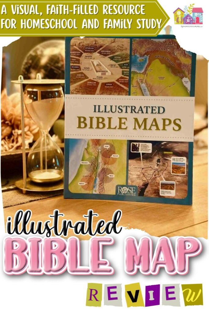
Illustrated Bible Maps is a sturdy softcover book, rich with information, but not too large for young hands to hold. Its pages move through Scripture in chronological order, guiding learners, children, and adults alike, through stories and sections of the Bible. Alongside each section are detailed maps, vivid illustrations, facts about biblical figures and customs, and other helpful tools. All of these elements work together to ground the stories of Scripture for readers by connecting them to physical places, people, and other interesting historical elements.
This resource is not a textbook or a workbook for any particular subject. Instead, it’s a beautiful and unique resource that families can use to connect Scriptural, historical, and geographical studies! As I get into the full review, I’ll cover: a little bit about the publishing company, what exactly is included in this book, some of our favorite features, and ways you can use this resource to bring Scripture to life in your homeschool and family learning!

About the Publisher- Rose Publishing
Illustrated Bible Maps is published by Rose Publishing, an imprint of Tyndale House Publishers. Many people know Rose Publishing for their visually rich Bible reference tools: maps, timelines, charts, and other resources that help bring Scripture to life. While I haven’t bought materials from Rose Publishing specifically before, I have personally had great experiences with Tyndale House Publishing materials. My daughter loves her NLT Girls’ Life Application Bible.
When I showed Illustrated Bible Maps to some friends, one of my friends said, “Oh, I see it’s from Rose. They always do great stuff!”
Inside the Book: Format, Features, and Sections
While Illustrated Bible Maps doesn’t go through every book of the Bible, it is arranged chronologically, beginning with Creation and moving all the way through the early Church. This timeline-style journey invites readers to follow the unfolding of Scripture in real places, from the mountains of Ararat to the Valley of Elah, the Sinai Peninsula, and Paul’s missionary journeys across the Mediterranean. These sections are also grouped in a way that emphasize biblical themes, adding another element to pull from for study and discussion.
Short, Easy-to-Navigate Sections
Each section is broken into manageable parts, making the book easy to skim or use. It’s not overwhelming, and you don’t have to read it cover to cover to benefit from it. Instead, you can turn directly to the section you’re studying and explore the visuals and commentary that bring it to life.
Visually Rich and Diverse
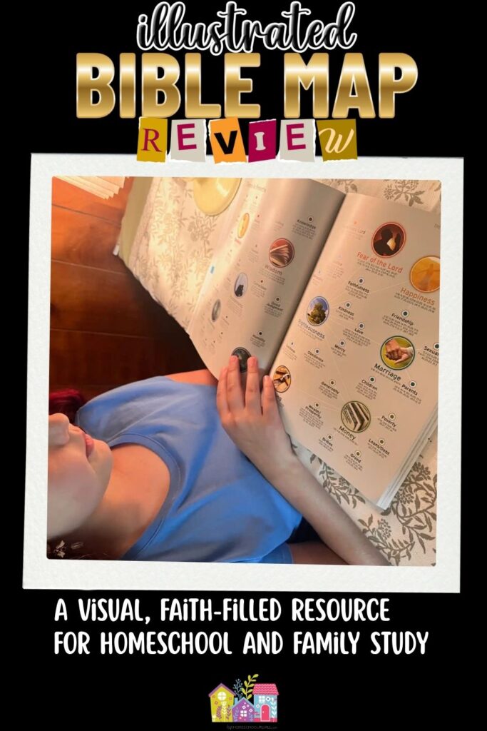
The visual elements of the Illustrated Bible Maps book are its strength. It’s a rich and beautiful resource, containing: over 100 full-color maps, illustrations, timelines, and photographs throughout the pages. The vivid maps and illustrations were my children’s favorite part of this resource, and I liked the way that these tools drew their attention while making information accessible at the same time.
Visual resources in Illustrated Bible Maps include:
- Timelines that help place biblical stories in historical context
- Maps that show where events happened in the real world
- Infographics explaining key points of Scripture at a glance, connecting the Old and New Testaments, and more.
- Pathways of key figures, such as Abraham, Moses, or Paul (and many more)
- Photos of modern-day locations, including the Holy Land and the mountains of Ararat
- Illustrated depictions of temples, altars, cities, and landscapes that offer visual insight into ancient life
The visual information is also arranged in a way that allows a logical flow of thought. For example, one of the early pages shows the mountains of Ararat, explaining that many believe this is where Noah’s Ark came to rest. On the next page, this also includes a map showing how ancient cities developed around those same mountains. These visual details and geographical facts led to some really great conversations between my older child and me about both history and faith.
A Section-by-Section Overview
Each major section in Illustrated Bible Maps endeavors to include key information from the books of the Bible it spans, and many connections are made between books and between the Old and New Testament, which was cool to see! This is definitely a very scholarly (but easy to use) resource for a family that hopes to prioritize Scriptural study. Here’s an overview of some of the information explored in the different sections.
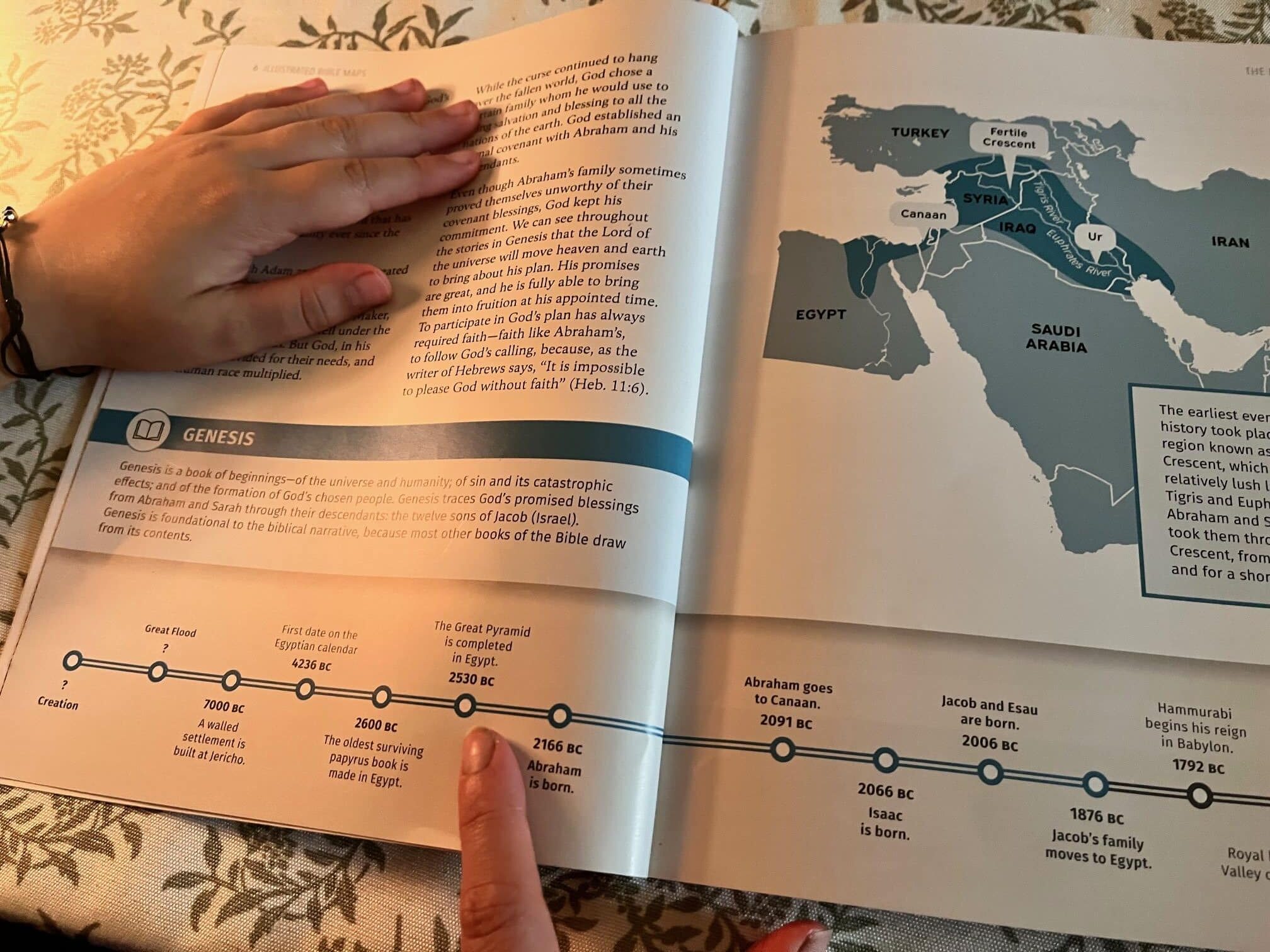
- The Beginning – this section covers Eden, the Flood, and the lives and journeys of key Biblical figures such as Abraham, Jacob, and Joseph. The family trees, timeline, and maps were a helpful way to see how God’s people traveled and expanded in ancient times.
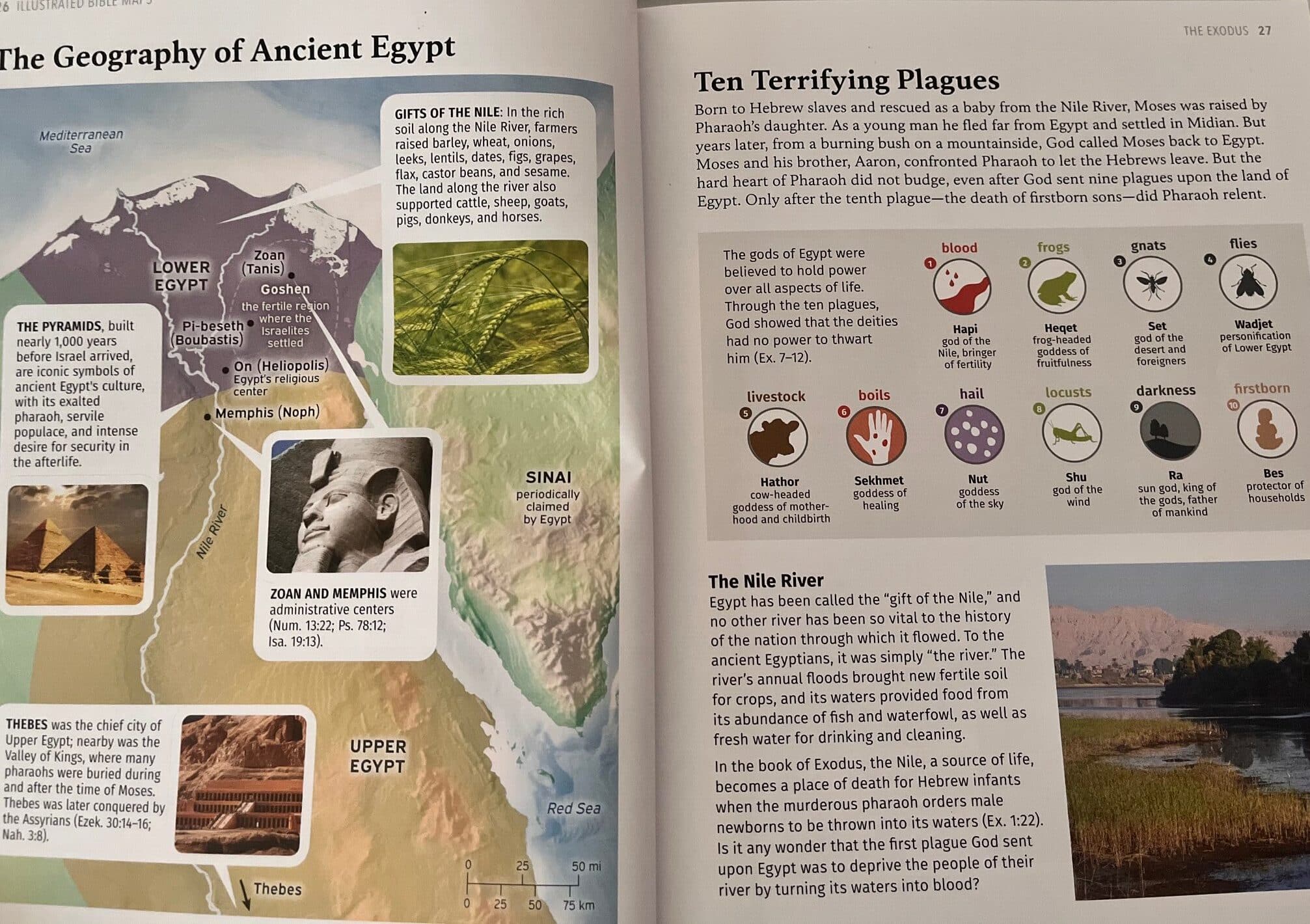
- Exodus – continues the story of Abraham’s family tree, the story of Moses (including visually accessible information about ancient Egypt, the 10 plagues, and more), the wandering in the desert, God’s presence in the Tabernacle, and God’s promised land.
- The Land – Highlights Pisgah Peak (where Moses saw the Promised Land), Joshua’s leadership and Jericho, the conquest and tribal allotments of Canaan, cities of refuge, an engaging infographic on the judges, and the story of Ruth.
- The Kingdom– Covers the rise of Israel’s monarchy through the books of Samuel, Kings, and Chronicles. This section follows key figures like Samuel, Saul, and David (from his early life as a shepherd to his reign as king). It includes a beautifully illustrated depiction of Jerusalem during David’s time, maps showing the expansion of his kingdom, and an infographic that explores the vast wealth and influence of King Solomon.
- The Books of Wisdom and Poetry – Focuses on key writings like Job, Proverbs, Ecclesiastes, and the Psalms. This section includes striking visual summaries and infographics that highlight major themes in Proverbs and Psalms, helping readers connect the poetic and moral wisdom of these books to the broader biblical narrative.
- The Kings & Prophets – This section revisits key moments from Kings, Chronicles, and the prophetic books. The timeline now includes major world events—like the founding of Rome—which provide broader historical context. Illustrated maps also trace the journeys of Elijah and Elisha, and the narrative spotlights figures like Ahab and Jezebel, Jonah, Hezekiah, Isaiah, and Josiah. This section also provides context about the Assyrians and the Babylonians, grounding prophetic messages in the political and geographic realities of the time.
- The Exile – Focuses on the period of exile and return, featuring stories, illustrations, maps, and infographics related to the rebuilding of Jerusalem and the messages of prophets like Jeremiah, Ezekiel, Daniel, Obadiah, Joel, Haggai, Zechariah, and Malachi. It also places the story of Esther within the context of the Persian Empire and connects this to conflicts that would continue into the New Testament.
- The Christ – This section explores the Gospels and the key places where Jesus lived, taught, and performed miracles, at times drawing connections back to the Old Testament. Maps and infographics trace Jesus’s journeys and miracles, and a detailed map of Jerusalem during His time mirrors the earlier map from David’s reign, offering an interesting point of comparison. The section also includes visuals related to the crucifixion, resurrection, and ascension, helping readers visualize the final days of Jesus’s earthly ministry.
- The Church – Tells the story of Christ’s followers after His ascension, tracing where they traveled and what they did as the early church took shape. This section includes detailed, annotated maps of Paul’s missionary journeys, insights into how the gospel spread throughout the book of Acts, and information about Paul’s companions. It also highlights key figures like Peter and John, and includes context for the seven churches of Revelation.
The organization of this text makes it easy to connect major themes of Scripture across different books of the Bible. It also allows students to “follow along with the story of God’s work in the world through his people,” as the publisher describes on the back of the book. The structure of this resource is valuable for learners, whether children or adults, because it brings together biblical history, geography, and storytelling in a way that builds understanding.
As a whole, I am so impressed by the biblical scholarship of this book. As an adult, I truly feel excited to continue exploring this resource, both with my children and for myself. There is much to learn, and there are many fascinating connections made between familiar biblical stories, geography, and other important historical events. The incredibly well-designed visual aids in this book make complicated information much simpler to understand and teach.

Spotlight: A Closer Look at “The Beginning.”
Let’s take a closer look, or “spotlight,” on the first section so that you can get a sense of how it can be read together and facilitate conversations! As a family, our homeschool history focused on the ancient world this year, and we also just wrapped up a study on The Odyssey. So, coming into Illustrated Bible Maps, we were already in a great place to appreciate the connections between ancient literature, geography, and Scripture. The section titled “The Beginning” was especially timely. It helped us build on that foundation and revisit some of the themes and locations we have recently been studying.
I love the timelines in every section because I’ve been wanting to integrate more timeline work into our homeschool. I just think it helps children see the bigger picture of when events take place, both in Scripture and in other areas of study. For the Genesis timeline particularly, I appreciated that it leaves the span of time between Creation and the Flood open-ended. This reflects the reality that Christians sometimes interpret those early chapters of Genesis differently. This, in particular, has been an ongoing conversation in our home, and resources like this give us room to acknowledge those differences while staying grounded in the truth of God’s Word.
We even used this timeline as a review activity, placing events from The Odyssey alongside Genesis to help frame both within a broader historical imagination.
As we worked through the text, we also found ourselves drawn into some deeper conversations by the narratives and the way the visual aids supported them. We talked about themes like God’s sovereignty and human rebellion, and how those ideas show up not just in Genesis but throughout the Bible. The map of the Fertile Crescent also gave us a chance to revisit our recent geographical studies of Mesopotamia and Egypt.
Most of all, this section served as a springboard for meaningful discussion with my family. We weren’t just learning dates and places, although we reviewed some of those things. Mostly, we were talking about God’s story and what that means for us today.
How to Use Illustrated Bible Maps in Your Homeschool
The Illustrated Bible Maps book is a versatile tool that fits seamlessly into a variety of homeschool subjects. In our family, we’ve seen how it could be used both as a stand-alone resource to spark conversations or as a bridge between Bible, geography, and literature. It opens space for natural, curiosity-driven questions such as: Where might the Garden of Eden have been? or, Are the places Paul traveled still around today?
If you’re looking for this, Illustrated Bible Maps would also pair well with unit studies: Old or New Testament, Ancient History, or even map-making. It’s also a natural fit for geography projects, like tracing missionary journeys, labeling ancient cities, or comparing biblical maps to modern ones. For Charlotte Mason-style homeschoolers, it can be used as a narration prompt or paired with student-created map illustrations.
With older students (middle or high school), this book can serve as a springboard into deeper conversations about archaeology, historical timelines, and biblical worldview. It reinforces interdisciplinary thinking by grounding Scripture in real places and times, many of which students will recognize from other studies.
In terms of age, I’d say that this one would be fine to explore with a parent or adult as a guide for most ages. For independent study, I’d suggest about 9 or 10 and up (depending on the child, of course)! While younger children may need a parent’s help to navigate, they will still enjoy the colorful illustrations and storytelling possibilities. For upper elementary and beyond, this book invites exploration across subjects.
But honestly, my favorite way to use this resource is to read it together as a family. Pair it with whatever you are reading in Scripture at the time, or what your church might be studying together. I think there’s a lot of benefit, for both parents and children, in reading this together. I am enjoying exploring the pages together with my children. It doesn’t have to be something we spend a long time on, but it has launched some meaningful conversations!

Final Thoughts on Illustrated Bible Maps
Illustrated Bible Maps is more than just a history or geography resource. It’s a springboard for meaningful conversation, a tool that helps families dig deeper into Scripture and explore big questions together. Whether you’re talking about God’s promises, the journey of His people, or the spread of the gospel, this book invites thoughtful conversations and exploration on every page. It fosters not only biblical knowledge but also spiritual reflection, something that’s deeply important in our homeschool.
While the engaging visuals make it accessible for children (especially ages 9 and up), the content is rich and well-researched enough for adults to learn from as well. This is not just a book for kids; it’s a beautiful, scholarly, and approachable tool for all ages.
If your student or family member ever asks, “Where did this happen?” or wants to connect Scripture to real places and real events, this book will quickly become a favorite. It brings biblical stories into sharper focus by grounding them in history, geography, and the larger narrative of God’s work in the world.
I recommend keeping Illustrated Bible Maps alongside your family Bible and other favorite biblical study tools. It’s a resource you can use, not just to help young learners engage with God’s Word, but to grow your own understanding and spark conversations that matter. Whether you’re reading together as a family, preparing to teach a homeschool lesson or Bible study, or simply wanting to explore Scripture in a deeper way for yourself or with your children, Illustrated Bible Maps is a worthy investment in lifelong learning and faith formation.