
TimeMaps Review & Giveaway {Closed}
Do you like maps? Boy, I sure do … there’s something about looking over all the outlines, colors, and labels that carries me away to distant and fascinating places. My own ‘weirdness’ aside, maps are a wonderful and very necessary tool for teaching our children about nations past and present.
I was very excited to get the chance to review a new product from Knowledge Quest – TimeMaps, the Maps that Move Through Time! These interactive maps use Flash to show how borders, settlements, and other features change and move over time.
The complete Collection includes seven map sets:
- Ancient China
- The Rise of the Roman Empire
- The Fall of the Roman Empire
- The Rise of Islam
- The Black Death
- European Exploration and Discovery
- The Atlantic Slave Trade
When a map is opened, the area is labeled with regions, cities, and other important information. In the upper right is the year represented by the map. Using arrows, the year can be changed, and the map changes accordingly. The color-coding and labels change, and brief animations show the movement of people groups or major events.
For example, take a look at the difference in the Roman Empire between 406 and 454 A.D.

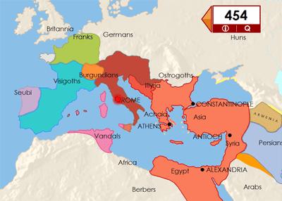
On each map, clicking “i” brings up a display box with information about that particular time in history. This section gives a nice overview of the time and briefly explains events that have caused changes since the previous map. Small graphics of buildings and people appear when the information box is visible – these graphics help clarify the locations of events.
On some maps, small icons appear in various spots when the information box is visible. Clicking on each of these gives additional information about the location. This was especially interesting to me on the maps showing the progression of the Black Plague where I learned that portions of Eastern Europe and Tibet escaped the plague because of their sparse populations and terrain. (I had wondered how most of Poland managed to avoid the Black Plague!)
Clicking “Q” brings up a list of questions about that particular map. The information and question boxes can be viewed at the same time or separately, which means you could use the questions as a quiz or for review.
Each map set comes with Teacher Notes in PDF that include an introduction, activity suggestions, and commentary on maps (which expands on the material in the information boxes). Also included are a printable blank timeline for your student to fill out and printable maps in both color and blackline.
I’m loving how TimeMaps enhances our regular studies. We’re studying the Middle Ages right now, and my oldest son (age 11) spends time looking at the maps, comparing the changes over time, and reading the information. I’m using the activity suggestions mostly as discussion ideas for now. Older students could certainly do the activities and writing exercises independently.
TimeMaps is available for both Mac and Windows computers. Each downloadable map set can be purchased separately for just $8.95, or the entire Collection can be purchased as a download for $39.95 or on CD-ROM for $42.95 plus S&H.
Find Knowledge Quest on Facebook and Twitter.
TimeMaps Giveaway

One Hip Homeschool Moms reader will win the TimeMaps Collection on CD-ROM!
(retail value $42.95)
Enter here . . .


Haven’t ever tried it…but would love to!
sounds wonderful! I too have always been fascinated with maps. Would LOVE this.
Awesome giveaway! I love finding new resources for our homeschool. I love History so I love the idea of looking back over time on the maps and seeing the differences evolve right before our eyes that way!
Sounds really great. We do not have a good source for maps!
We just added time lines to our curriculum. This would be a great addition!
This looks great. Thanks for the chance to win this.
This looks like it would be fun and very informative. My 8 yr old loves learning about where places are.
My history kid would look at these maps for hours! OK, and so would I. He gets his love of history from his mama. The visual representation of the rise and fall of civilizations would cement so much of his understanding of history. Oh, I hope I win!
My two boys love maps so this would be great for them. Thanks for giving us the chance to win this.
I love how this allows children to see the actual changes in boundaries/land that they read about in their History/Geography books. Our kids are very visual learners so this would be a great addition for them.
I love maps and history!!! This looks like an amazing resource! Much better than what I do now: stand on a chair and use a wipe off marker to write on our map on the wall. 😉
These look awesome! My son loves maps!
We would love to win this map set. Thanks for the opportunity!
Blessings,
Lori
I totally love the TimeMap concept!! They’re multi-sensory and combine timelines with maps. What’s not to love? We love history and we love maps–this is a total win/win situation!
These look like fun!!!
What I like best is that these look so easy to read, with the simple font and all the vibrant colors.
I LOVE MAPS!!!
This would be so great- I hope I win 🙂
We love maps here!
I love maps, and the fact that you can easily compare areas over different time periods looks awesome!!
I love maps, and it sounds like these bring changes to life.
I was a geography major, and I LOVE maps. Looking at maps are great… but how cool is it to have an interactive map!!
Love this! I’d love to bring this into our homeschool! 🙂
I like having such detailed maps at my fingertips. Thank you.
That looks so cool!!! I would love it! And I’m sure my kids would too.
I so desperately need some maps! I’ve been so frustrated this year with not being able to find what I need for our history studies. This would be fabulous!
love the colors
We love maps however having the teacher notes is probably a wonderful addition!
My son has always loved maps! I know he would love it if I won this. 🙂 Thanks for the chance to enter.
This looks incredible. My 10 year old has been crazy about maps since she was 3 years old.
I would love to win this. I love maps and have just been researching timelines!
I love history and maps! This would be awesome:)
What I like best is that it helps give a perspective of what is going on versus what something just looks like. This seems like a terrific product!
Wow! What a cool product. My kids would LOVE to use this.
I’m SUCH a map person! I think my favorite part about this program is that you can see the changes over time. How cool is THAT!! 🙂
I LOVE maps and anytime I find one, I share it with my boys. They have no idea how much history and geography they have already learned!
As a very visual person, this is freakin’ awesome! We’ve been enjoying a number of different maps this year and this would really bring our history to life!
Great software …my kids would enjoy this!
I am very excited about how these coincide with what we are learning in history. These will be so beneficial to get an in your face visual play by play of how each country was changed and affected during history. This is awesome, thank you for bringing it to my attention.
We would lot to win this! They are so bright and colorful!
The maps look great and would be a wonderful asset to our homeschool.
I love the colors! Would be a great addition to our homeschool class room!
Oh this would be awesome!!!! What a great addition to our homeschool! Plus, my son is sooo interested in maps right now so he would love it too!
I just love how the maps are so user and child friendly. Sounds like a awesome teaching tool that I would be very blessed (not to mention excited) to use. 🙂
I have never seen anything like these maps! That is such a neat concept!
What a great giveaway! We love maps!
I like how they evolve. Very cool and love the technology involved.
Oh How I need this!!!
Would love to add this to our homeschooling curriculum! 🙂
LOVE HISTORY AND LOVE MAPS!
This program looks like a great way to see the history change the countries and learn what influences changed the culture.
Love how colorful the maps are. They grab your attention.
My son would love this. He has a love for maps.